Navigating coastal waters, vast lakes, or intricate river systems requires precision and reliability. A quality marine GPS unit is more than just a map; it’s your essential guide for safety, efficiency, and finding your way back to port or your secret fishing spot. With options ranging from simple handhelds to advanced multi-function chartplotters, choosing the right one is key to a confident day on the water.
This roundup features ten of the best marine GPS and fishfinder units available, each catering to different needs and budgets. Whether you’re a casual boater, a competitive angler, or someone who needs a rugged portable device, there’s a solution here to enhance your maritime adventures and provide peace of mind during every voyage.
Our Top Picks for Marine GPS and Navigation
- Simrad Cruise 9-inch GPS Chartplotter with Transducer
- Lowrance HOOK Reveal 5 Inch Fish Finders with Transducer
- Garmin GPSMAP 78sc 2.6-Inch Waterproof Marine GPS
- Garmin ECHOMAP UHD 93sv with GT56UHD-TM Transducer
- Humminbird Helix 15 Chirp MEGA DI+ GPS G4N CHO
- Garmin Striker Vivid 9sv Bundle with Transducer and Cover
- Eagle 9 TripleShot HD with C-MAP Inland Charts
- Garmin GPSMAP 943xsv Combo GPS/Fishfinder
- Humminbird PiranhaMAX 4 Fish Finder with Transducer
- Garmin GPSMAP 8612xsv Chartplotter with GT56UHD-TM Transducer
Simrad Cruise 9-inch GPS Chartplotter with Transducer
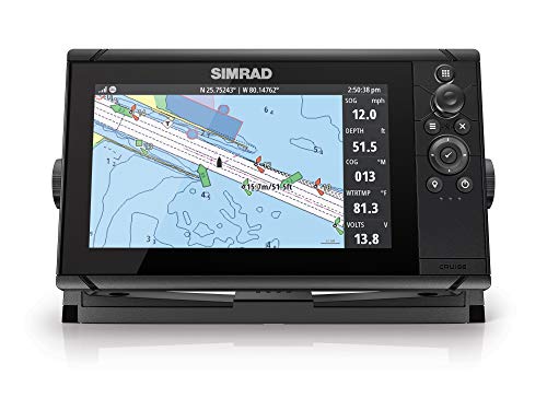
Designed for straightforward and reliable navigation, the Simrad Cruise chartplotter is built for boaters who value simplicity. It comes ready to use right out of the box with preloaded C-MAP US coastal maps, providing all the essential chart data you need for a day on the water. This eliminates the hassle of purchasing and loading maps separately.
The interface is notably intuitive, featuring clear menus and a combination of rotary dial and keypad controls for effortless operation. The 9-inch display offers a good balance of size and clarity, making it easy to view your course and surroundings. It also supports enhanced charts from major providers, allowing for future upgrades if your navigation needs become more advanced.
Lowrance HOOK Reveal 5 Inch Fish Finders with Transducer
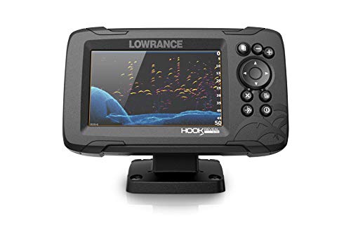
This unit is an excellent entry point for anglers seeking a capable fishfinder with basic GPS plotting. The standout feature is FishReveal technology, which combines standard CHIRP sonar with DownScan Imaging to make fish and structure distinctly clearer on the display, helping you identify what’s below your boat more effectively.
Equipped with a GPS plotter, it allows you to mark waypoints, create routes, and follow trails to return to productive fishing locations. The included SplitShot transducer provides a versatile view beneath the surface. Note that this model does not include preloaded maps, focusing its value on sonar performance and core GPS tracking functions.
Garmin GPSMAP 78sc 2.6-Inch Waterproof Marine GPS

For those who need a portable and rugged navigation solution, the Garmin GPSMAP 78sc is a reliable handheld choice. Its compact size and waterproof design (IPX7) make it perfect for kayaking, dinghy use, or as a backup device on larger vessels. A significant advantage is that it actually floats if dropped overboard.
It comes preloaded with BlueChart g2 charts for the U.S. and Bahamas, featuring detailed coastal data like depth contours, navigation aids, and marina information. The high-sensitivity GPS receiver ensures strong signal acquisition even in challenging conditions, providing dependable positioning wherever your adventures take you.
Garmin ECHOMAP UHD 93sv with GT56UHD-TM Transducer
This model is a powerful all-in-one unit that excels in both navigation and detailed sonar imaging. The bright 9-inch touchscreen is easy to read in direct sunlight and includes physical keys for reliable operation in all conditions. It is preloaded with U.S. LakeVü g3 maps, offering exceptional detail for inland fishing and boating.
The included GT56UHD-TM transducer delivers comprehensive sonar coverage, including traditional CHIRP, Ultra High-Definition ClearVü, and SideVü scanning sonar. The vivid scanning sonar color palettes help distinguish between fish, structure, and the bottom with remarkable clarity, giving you a distinct advantage on the water.
Humminbird Helix 15 Chirp MEGA DI+ GPS G4N CHO

Featuring a massive 15-inch display, this Humminbird Helix model is built for anglers who need maximum screen real estate to view multiple data points at once. It is a Control Head Only (CHO) unit, meaning it is designed to integrate into an existing network or connect to specialized transducers like MEGA 360 Imaging or those built into compatible trolling motors.
It operates via a straightforward keypad control system, allowing for quick access to preloaded views and reliable performance in wet conditions. The unit supports MEGA Down Imaging+ sonar, which provides exceptional clarity and detail for identifying fish-holding structure, making it a professional-grade tool for serious fishing.
Garmin Striker Vivid 9sv Bundle with Transducer and Cover
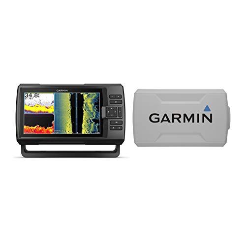
The Garmin Striker Vivid 9sv bundle offers excellent value by combining a capable fishfinder and GPS plotter with a protective cover. The 9-inch display uses vivid scanning sonar color palettes that are engineered to help you differentiate between targets, making it easier to interpret what you’re seeing below the surface.
This all-in-one package includes the necessary transducer for traditional sonar, ClearVü, and SideVü scanning sonar. The included protective cover is a practical addition for keeping your unit safe from the elements and during transport. It’s a solid choice for anglers looking for a comprehensive setup without separate purchases.
Eagle 9 TripleShot HD with C-MAP Inland Charts

Eagle by Lowrance provides a feature-rich package with this 9-inch unit. It comes preloaded with C-MAP Inland Charts covering over 17,000 American lakes, giving you immediate access to detailed contours and points of interest. The high-visibility IPS screen ensures the display remains clear and crisp even in bright sunlight and when viewed at an angle.
The newly designed TripleShot HD transducer offers improved clarity and performance, featuring CHIRP sonar, DownScan Imaging, and FishReveal technology. A practical twist-lock connector system makes installation and removal simple, which is ideal for anglers who use multiple boats or need to secure their gear.
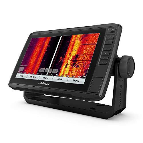
Garmin GPSMAP 943xsv Combo GPS/Fishfinder

This advanced chartplotter is built for boaters and anglers who demand premium mapping and networking capabilities. It arrives preloaded with a massive library of charts, including U.S., Canada, and Bahamas BlueChart g3 coastal maps plus LakeVü g3 inland maps, offering exceptional coverage for various types of voyages.
The GPSMAP 943xsv is designed to be the centerpiece of a sophisticated marine electronics network. It supports radar, audio, and additional sonar modules, allowing you to build a complete command system on your boat. The high-resolution display and powerful processor handle complex chart data and multiple data overlays with ease.
Humminbird PiranhaMAX 4 Fish Finder with Transducer

An ideal starter unit, the Humminbird PiranhaMAX 4 focuses on the essentials of fish finding at an accessible level. Its dual-beam sonar allows you to switch between a narrow beam for detailed, focused views and a wide beam for covering more area, helping you locate fish and understand bottom composition.
Portability is a key benefit. The included soft-sided carrying case and a versatile tilt-and-swivel mount make it simple to install on a small boat, kayak, or even temporarily on a rental. This makes it a great tool for anglers who are just beginning or who need a simple, transportable sonar solution.
Garmin GPSMAP 8612xsv Chartplotter with GT56UHD-TM Transducer
Representing the high end of marine navigation, this large-format 12-inch chartplotter is designed for serious offshore boating and fishing. The expansive, ultra-high-resolution display provides ample space for splitting the screen between detailed mapping, advanced sonar imagery, and other vital data streams, all visible at a glance.
Paired with the powerful GT56UHD-TM transducer, it delivers top-tier CHIRP traditional sonar and Ultra High-Definition scanning sonar. This combination offers unparalleled views below and to the sides of your boat. It is built for integration into a full Garmin marine network, supporting radar, cameras, and autopilot systems for complete vessel control.
How to Choose a Marine GPS Unit
Picking the right marine GPS unit is about more than just seeing where you are on a map. It’s about matching the tool to your boat, your budget, and how you use the water. I’ve spent a lot of time comparing units, and here’s what I always consider before making a choice.
First, think about screen size and readability. A 4-inch screen might be fine for a small center console, but if you have a larger helm or need to view detailed charts and radar overlays, you’ll want a 9-inch or larger display. Brightness is critical, too. You need a screen that’s easily visible in direct sunlight, so look for high-nit ratings. Touchscreen interfaces are now standard and very intuitive, but having physical buttons as a backup is a smart feature for when it’s rainy or your hands are wet.
Next, consider connectivity and integration. Modern marine GPS units are the hub of your boat’s electronics. You’ll want one that can connect via NMEA 2000 to your engine data, depth sounder, autopilot, and radar. Built-in Wi-Fi and Bluetooth are almost essential for wireless updates, connecting to your smartphone for notifications, or streaming music. Some units even allow you to mirror charts to a tablet as a secondary display.
Charting is the heart of any GPS. Most brands offer their own detailed cartography, but you need to check if the regions you navigate are pre-loaded or require an additional purchase. Look for features like relief shading, satellite overlay imagery, and auto-routing. For coastal and offshore use, having support for multiple chart types is a big plus.
Finally, durability is non-negotiable. The unit must be waterproof (look for an IPX7 or higher rating), resistant to UV rays, and built to handle the constant vibration and temperature swings on a boat. Your investment needs to last in the harsh marine environment. By focusing on these key areas—display, connectivity, charts, and build—you can narrow down the list of the 10 best marine GPS units for navigation to find the perfect model for your voyages.
FAQ
What’s the difference between a chartplotter and a fishfinder combo?
This is a common point of confusion. A basic chartplotter is designed primarily for navigation, displaying your position on marine charts, creating routes, and marking waypoints. A fishfinder combo unit does all of that and includes a sonar transducer to show what’s below your boat—the water depth, bottom contour, and fish arches. If you only care about navigation, a chartplotter is sufficient. But for most boaters, especially anglers, the combo unit offers much better value and consolidates two devices into one.
Do I need to pay for chart updates, and how often?
Yes, chart updates are typically a separate cost after your initial purchase, though some units include a year of updates. Navies and surveyors are constantly updating data for hazards, channels, and aids to navigation, so keeping your charts current is a major safety practice. I recommend updating at least once per season. Many manufacturers offer subscription plans, making it easier to get annual updates.
Can I use a handheld marine GPS as my primary unit?
You can, but with significant limitations. Handhelds are fantastic as backups or for use on a dinghy or kayak. Their screens are small, which makes detailed navigation tricky at speed. They usually have less powerful processors and smaller internal memory. For a primary unit on your main vessel, a fixed-mount marine GPS chartplotter with a larger, brighter display is a far safer and more functional choice.
How important is network connectivity on a marine GPS?
In my opinion, it’s very important for modern boating. NMEA 2000 network connectivity lets your GPS talk to other critical systems. Seeing your fuel flow, engine RPM, and water temperature right on the chart screen is incredibly useful. It also allows for advanced features like controlling a trolling motor from the chartplotter or having your autopilot follow a route you’ve plotted. It turns your GPS from a simple map into a true command center.
What are the key features for offshore versus inland use?
For offshore or coastal cruising, you’ll want a unit with detailed offshore charts, radar overlay compatibility, and the ability to interface with satellite communication systems for weather and messaging. For inland lakes and rivers, look for units with exceptionally detailed inland cartography that shows submerged structures, depth contours, and navigable channels. Inland boaters often benefit from side-scanning sonar features for understanding the bottom layout around them.